
GARMIN GPS72
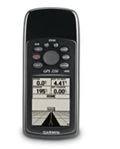
SPECIFICATION
- Navigation features
- Waypoints/icons: 500 with name and graphic symbol, 10 nearest (automatic), 10 proximity
- Routes: 50 reversible routes with up to 50 points
- each, plus MOB and TracBack® modes
- Tracks: Automatic track log; 10 saved tracks let
- you retrace your path in both directions
- Trip computer: Average speed, resettable max. speed, trip timer and trip distance
- Alarms: Anchor drag, approach and arrival, off-course, proximity waypoint, shallow water and deep water
- Tables: Built-in celestial tables for best times to fish and hunt; sun and moon rise, set, and location
- Map datums: More than 100 plus user datum
- Position format: Lat/Lon, UTM/UPS, Maidenhead, MGRS, Loran TDs and other grids, including user grid
- GPS performance
- Receiver: WAAS-enabled, 12 parallel channel
- GPS receiver continuously tracks and uses up to 12 satellites to compute and update your position
- Acquisition times:
- Warm: Approximately 15 seconds
- Cold: Approximately 45 seconds
- AutoLocate™: Approximately 5 minutes
- Update rate: 1/second, continuous
- GPS accuracy:
- Position: < 15 meters, 95% typical*
- Velocity: 0.05 meter/sec steady state
- DGPS (USCG) accuracy:
- Position: 3-5 meters, 95% typical
- Velocity: 0.05 meter/sec steady state
- DGPS (WAAS) accuracy:
- Position: < 3 meters, 95% typical
- Velocity: 0.05 meter/sec steady state
- Dynamics: 6 g’s
- Interfaces: RS232 with NMEA 0183, RTCM 104 DGPS data format and proprietary GARMIN
- Antenna: Built-in quadrifilar
- Differential: DGPS, USCG and WAAS capable
- Moving map features
- Basemap: Marine database. Preloaded with worldwide cities, navaids,and U.S.A. tide data
- Uploadable maps: Accepts up to 1 megabyte of
- data from the optional MapSource™
- Points of Interest CD**
- Power
- Source: External power, 8-35V; two “AA” batteries (not included)
- Battery life: Up to 16 hours
- Physical
- Size: 2.7"W x 6.2"H x 1.2"D (6.9 x 15.7 x 3.05 cm)
- Weight: 7.7 oz. (225 g)
- Display: 1.6"W x 2.2"H (4.1 x 5.6 cm)
- 120 x 160 pixels, high-contrast
- FSTN with bright backlighting
- Case: Fully gasketed, high-impact plastic alloy,waterproof to IEC 529 IPX7 standards
- Temp. range: 5ºF to 158ºF (-15ºC to 70ºC)
- User data storage: Indefinite, no memory battery required
- Accessories
- Standard: Owner’s manualQuick reference guide Wrist strap
- Optional: Automotive mount Marine mount
- Carrying case 12-volt adapter cable
- Power/data cable MapSource™ Points of Interest CD Instructional video PC interface cable
Enquiry Form
Related Product


Tesca specialize in doing turnkey projects that is fully operable when it is handed over to the project authority. Starting from inception to application training, Tesca provides the services as ONE source solution. Working side by side with government authorities and people across the World, we help countries to perform better. We support countries grow their economies, strengthen their education and health systems and improve financial management. We do this by providing consultancy & training in environment safety, education, health strengthening.
Category
Useful Links
Contact Us
International Sales:
 91-9829132777
91-9413330765
India Sales:
91-9588842361
2026 © All Rights Reserved.